Drones in Architecture
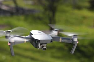
ELK RIVER WATER TOWER Problem: How do you field measure a water tower in the middle of a Minnesota winter? A. Risk your life to climb an icy freezing slippery ladder and use a tape measure and laser pointer to get an approximation of size. B. Fly a drone and take pictures and use these images to create a point cloud and Revit family with exact dimensions. Answer: B: Fly a drone. Working with the City of Elk River and CAD Technology Center (CTC), an Unmanned Aerial Vehicle (UAV aka Drone) was flown the morning of February 8, 2018. The drone set-up and flight only took a few hours and the flight created a photo scan of the water tower by taking hundreds of digital photos. CTC processes the data and created a point cloud file in Revit. From this file, a Revit family component was created that is a full sized three-dimensional digital representation of the water tower After Kodet received the Revit model, some detail had to be added to the model, but the basic dimensions, size, shape, and heights were a part of the model created from the photo scan. Kodet used this model to create drawings for contractors to estimate renovation costs to repaint the historical water tower. Countless hours were saved in field time and modeling time. In the end, a much more accurate set of drawings were created because of the use of the drone. The documentation process to get contractors to be able to bid the project became very simple and cost effective. The client was also pleased with the results and accuracy of the drawings that were created by the UAV Scan. Our office looks forward to using this highly advanced technology, which is constantly changing on future projects. Flying […]